


by Kate Evans
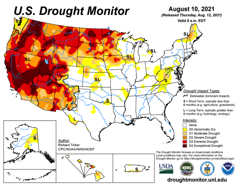
Recent welcome rains may have helped the area avert a serious dry spell. However, according to the United States Drought Monitor Classification system, the Eastern Panhandle of West Virginia, along with much of the state, is classified right now as abnormally dry — the lowest level of drought. Data is current as of August 10 on their August 12 map.
A strip of counties or partial counties near the central part of West Virginia are considered in moderate drought as are portions of western Maryland.
Small portions of Mineral, Grant and Pendleton Counties are being affected by moderate drought.
Western Allegany County is also considered in moderate drought while the rest of the county is abnormally dry. Washington County in Maryland is completely classified as abnormally dry, as are half of Fulton and Franklin Counties in Pennsylvania.
Impacts
Some possible impacts of drought mentioned on the U.S. Drought Monitor website for the first level of drought include: crop growth is stunted, fire danger is elevated, lawns brown early, gardens start to wilt and surface water levels decline.
In moderate drought areas, possible effects include an increase in irrigation use, lower hay and grain yields than normal, wildfires and ground fires increase, trees and landscaping are stressed, fish are stressed and reservoir and lake levels are below normal. Voluntary water conservation may be requested.
Different types of drought
Climatologists have defined four different types of drought that can occur — meteorological drought, hydrological drought, agricultural drought and socioeconomic drought.
“Meteorological drought happens when dry weather patterns dominate an area. Hydrological drought occurs when low water supply becomes evident especially in streams, reservoirs, and groundwater levels, usually after many months of meteorological drought. Agricultural drought happens when crops become affected. And socioeconomic drought relates the supply and demand of various commodities to drought,” said officials.
Precipitation
The National Weather Service in their forecast last week noted that “subnormal rainfall in the central Virginias prompted the introduction of abnormal dryness across most of West Virginia and adjacent western Maryland, where deficits of 2.5 to locally 4.0 inches have developed over the past couple of months.”
National Weather Service meteorologist Jeremy Geiger from the Baltimore/Washington Weather Forecast Office said that the area had 3.88 inches of rain this June recorded at the Martinsburg airport weather station. Geiger said that the average rainfall in June since the year 2000 has been 4.14 inches. June was slightly below normal in precipitation.
The rainfall for July of this year was 2.39 inches and the 20-year average for July was 3.72 inches. July fell around one and a half inches below normal in rainfall.
The month of August to date has had .54 inches of rain.
Cacapon State Park station
Geiger said that the Cacapon State Park weather station recorded much more rainfall than the Martinsburg station. It reported 6.61 inches of rain for June and 1.16 inches of rain in July. The weather station showed 2.33 inches of rain to date in August.
The Cacapon weather station showed an average rainfall of 5.77 inches in June over 15 years of data. July had an average of 4.51 inches of rain over 15 years. Geiger said that the station was missing months of data in some years.
Geiger said that this week’s forecast has multiple rainstorms and showers with every day having a chance of rain. Most of the precipitation will fall late Tuesday though Wednesday night. Temperatures are also expected to be a little lower, with daily highs ranging from 78 to 86 degrees and nighttime temperatures ranging from 63 to 67 degrees. All help to ease the dry conditions.


